City of Gosnells
About the profile areas
The 2023 Estimated Resident Population for the City of Gosnells is 137,355, with a population density of 1,079 persons per square km.
Location and boundaries
The City of Gosnells is located in Perth's south-eastern suburbs, about 17 kilometres from the Perth CBD. The City of Gosnells is bounded by the City of Kalamunda in the north-east and east, the City of Armadale in the south, and the City of Canning in the west and north-west.
Traditional Owners
The original inhabitants of the Gosnells area were the Beeloo Aboriginal people.
Name origin
Gosnells is named after Charles Gosnells, an early land holder in the area, and director of John Gosnell and Co. perfumery and cosmetic manufacturers.
Important
|
Population137,355 2023 ABS ERP |
Land area127.3 square km |
Population density1,079 persons per square km |
Settlement history
European settlement dates from 1829, when farming commenced along the Canning River. A number of small settlements were established, with land used mainly for agricultural purposes, particularly farming and orcharding. Population was minimal until the early 1900s when land was subdivided. Land continued to be used largely for market gardens, orchards and poultry farms. Significant development did not occur until the post-war years. The population grew from 7,400 in 1954 to about 11,000 in 1966, and then to 21,000 in 1970. From the 1950s to the 1980s rapid growth took place along the Albany Highway, the Canning River and the Southern River (the suburbs of Beckenham, Gosnells, Kenwick, Langford, Maddington and Thornlie). The suburb of Huntingdale was developed from the 1970s. The population of the City continued to increase from the early 1990s, rising from 69,500 in 1991 to 105,000 in 2011. Much of this growth has been from new residential development in the suburbs of Canning Vale and Southern River, and to a lesser extent in the suburb of Gosnells from the construction of flats and apartments. Population growth is expected to continue.
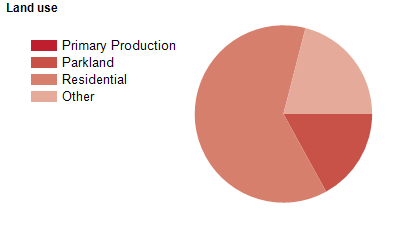
Land use
The City of Gosnells is a growing residential area, with substantial rural areas in the east and south, and some commercial and industrial areas, particularly along the Albany Highway. The majority of the population live in suburbs west of the Albany Highway. The City encompasses a total land area of about 128 square kilometres, with substantial areas of state forest.
Transport
The City of Gosnells is served by the Albany Highway, the Roe Highway, the Tonkin Highway and the Armadale and Thornlie railway lines.
Major features
- Major features of the City include the Canning River,
- Polytechnic West (Thornlie Campus),
- Centro Maddington (shopping centre),
- Hometown Cannington (commercial centre),
- Don Russell Performing Arts Centre,
- City of Gosnells Museum - Wilkinson Homestead,
- Gosnells Golf Club,
- Korung National Park,
- Banyowla Regional Park,
- Langford Park Sporting Complex,
- Tom Bateman Sporting Complex,
- Sutherlands Park and the Canning River parklands.
Included areas
- The City of Gosnells includes the suburbs and localities of Beckenham,
- Canning Vale (part),
- Gosnells,
- Huntingdale,
- Kenwick,
- Langford,
- Maddington,
- Martin,
- Orange Grove,
- Southern River and Thornlie.