Golden Plains Shire
About the profile areas
The 2023 Estimated Resident Population for Golden Plains Shire is 25,818, with a population density of 9.56 persons per square km.
Location and boundaries
Golden Plains Shire is located in south-western Victoria, about 80-160 kilometres from the Melbourne CBD, 10-100 kilometres from the Geelong CBD, and 10-80 kilometres from the Ballarat CBD. Golden Plains Shire is bounded by the City of Ballarat and Moorabool Shire in the north, the City of Greater Geelong in the east, Surf Coast Shire and Colac Otway Shire in the south, and Corangamite Shire and Pyrenees Shire in the west.
Traditional Owners
The original inhabitants of Golden Plains Shire were the Wadawarrung and Eastern MaarAboriginal peoples.
Name origin
Golden Plains Shire is named for the rich gold mining history of the area.
Important
|
Population25,818 2023 ABS ERP |
Land area2,702 square km |
Population density9.56 persons per square km |
Settlement history
European settlement dates from the 1830s, with land used mainly for grazing, farming and timber-cutting, especially near the rivers. Growth took place in the 1850s and 1860s, particularly in the townships of Bannockburn, Linton, Scarsdale, Smythesdale and Steiglitz, spurred by gold discoveries. Growth continued through to the late 1800s, aided by the construction of the railway line in the 1860s. Significant development occurred during the post-war years, with steady population growth from the 1970s. The majority of recent population growth has been in the south-east and north-east of the Shire, in the areas closest to Geelong and Ballarat.
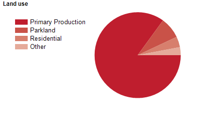
Land use
Golden Plains Shire is a predominantly rural area with numerous townships. The largest town is Bannockburn, with smaller townships at Batesford, Enfield, Inverleigh, Lethbridge, Linton, Meredith, Smythesdale and Teesdale, and numerous small villages and communities. The Shire encompasses a total land area of about 2,700 square kilometres. Rural land is used mainly for sheep and cattle grazing and cropping, with some gold mining, viticulture, poultry farming and pig growing.
Transport
Golden Plains Shire is served by the Glenelg Highway, the Hamilton Highway and the Midland Highway.
Major features
- Major features of Golden Plains Shire include Brisbane Ranges National Park,
- Enfield State Park,
- Steiglitz Historic Park,
- Devils Kitchen Geological Reserve,
- several state forests,
- The Moorabool River,
- The Ballarat-Skipton Rail Trail,
- Jubilee Mine Historic Area and numerous wineries.
Included areas
- Golden Plains Shire includes the localities of Anakie (part),
- Bamganie,
- Bannockburn,
- Barunah Park,
- Batesford (part),
- Berringa,
- Berrybank (part),
- Cambrian Hill,
- Cape Clear,
- Corindhap,
- Cressy (part),
- Dereel,
- Durdidwarrah,
- Durham Lead (part),
- Enfield,
- Garibaldi,
- Gheringhap,
- Grenville (part),
- Haddon,
- Happy Valley,
- Hesse,
- Illabarook,
- Inverleigh (part),
- Lethbridge,
- Linton (part),
- Mannibadar,
- Maude,
- Meredith (part),
- Morrisons (part),
- Mount Bute (part),
- Mount Mercer,
- Murgheboluc,
- Napoleons,
- Newtown,
- Nintingbool,
- Piggoreet,
- Pitfield,
- Pittong (part),
- Rokewood,
- Rokewood Junction,
- Ross Creek,
- Russells Bridge,
- Scarsdale,
- She Oaks,
- Shelford,
- Smythes Creek (part),
- Smythesdale (part),
- Springdallah,
- Staffordshire Reef,
- Steiglitz,
- Stonehaven,
- Sutherlands Creek,
- Teesdale,
- Wallinduc,
- Werneth (part),
- Willowvale and Wingeel (part).