Shire of Gingin
About the profile areas
The 2023 Estimated Resident Population for the Shire of Gingin is 6,064, with a population density of 1.89 persons per square km.
Location and boundaries
The Shire of Gingin is located in the Wheatbelt Region of Western Australia, between 60 and 130 kilometres north of the Perth CBD. The Shire of Gingin is bounded by the Shire of Dandaragan and the Shire of Victoria Plains in the north, the Shire of Chittering in the east, the City of Wanneroo in the south, and the Indian Ocean in the west.
Traditional Owners
The original inhabitants of the Gingin area were the Yued Noongar Aboriginal people.
Name origin
The Shire of Gingin is named from an Aboriginal word, perhaps meaning “footprint” or “place of many streams”.
Important
|
Population6,064 2023 ABS ERP |
Land area3,215 square km |
Population density1.89 persons per square km |
Settlement history
European settlement dates from the 1830s when the area was first explored, with land used mainly for farming. Population was minimal until the 1860s when the townsite of Gingin was established. Some growth took place from the late 1800s into the early 1900s, spurred by the opening of the railway line from Gingin to Geraldton in 1891. The population of the Shire reached nearly 700 in 1911. The most significant development occurred from the 1960s, with the population growing from under 800 in 1961 to about 1,200 in 1971. More rapid growth took place from the 1970s, with the population rising to about 1,900 in 1981 and then to about 2,600 in 1991. The population continued to increase from the 1990s, rising to about 4,500 in 2011, as new dwellings were added and dwelling occupancy rates increased. Growth is expected to continue.
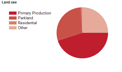
Land use
The Shire of Gingin is predominantly rural, with small, growing townships at Gingin, Guilderton, Lancelin, Ledge Point and Seabird. The Shire encompasses a total land area of about 3,200 square kilometres. Rural land is used largely for agriculture, particularly cattle and sheep grazing, and horticulture, with some viticulture. Tourism is also an important industry, particularly in the coastal areas.
Transport
The Shire of Gingin is served by the Brand Highway, Lancelin Road and Wanneroo Road.
Major features
- Major features of the Shire include Moore River National Park,
- Boonanarring Nature Reserve,
- Nilgen Nature Reserve,
- Yeal Nature Reserve,
- Lancelin Sand Dunes,
- Guilderton Sunken Pinnacles,
- various beaches,
- Gravity Discovery Centre,
- several wineries,
- Gingin Aquatic Centre,
- Gingin Brook and the Moore River.
Included areas
- The Shire of Gingin encompasses the localities of Bambun,
- Beermullah,
- Boonanarring,
- Breera,
- Breton Bay,
- Caraban,
- Coonabidgee,
- Cowalla,
- Cullalla,
- Gabbadah,
- Gingin,
- Ginginup,
- Granville,
- Guilderton,
- Karakin,
- Lancelin,
- Ledge Point,
- Lennard Brook,
- Mindarra,
- Moondah,
- Moore River National Park,
- Muckenburra,
- Neergabby,
- Nilgen,
- Orange Springs,
- Red Gully,
- Seabird,
- Wanerie,
- Wilbinga,
- Woodridge and Yeal.