G21 Region
About the profile areas
The 2023 Estimated Resident Population for the G21 Region is 373,430, with a population density of 41.75 persons per square km.
Location and boundaries
The G21 (Geelong Region Alliance) Region is located in south-western Victoria, between 75 and 160 kilometres from the Melbourne CBD. The G21 Region is bounded by Pyrenees Shire, the City of Ballarat and Moorabool Shire in the north, the City of Wyndham and Port Phillip Bay in the east, Bass Strait in the south, and Corangamite Shire in the west.
Traditional Owners
The original inhabitants of the G21 Region were the Coladjin, Gadubanud, Gulidjan and Wadawurrung (Wathaurong) Aboriginal people.
Important
|
Population373,430 2023 ABS ERP |
Land area8,944 square km |
Population density41.75 persons per square km |
Settlement history
European settlement dates from the 1830s, with land used mainly for timber-getting, farming, grazing and vineyards. Growth was minimal until the 1840s, when many small townships were established. Expansion took place from the 1850s to the late 1800s, particularly in Geelong, aided by improved access, the gold rush and the establishment of industries. Gradual population growth continued in the early 1900s. The most significant development occurred in the post-war years, particularly during the 1960s and 1970s, aided by the rapid expansion of industry, immigration, the construction of public housing estates and tourism. Population growth continued from the 1980s, particularly from the late 1990s. Recent population growth has largely been in the fringes of the Geelong urban area, as well as the Bellarine Peninsula, the Surf Coast, and various coastal towns.
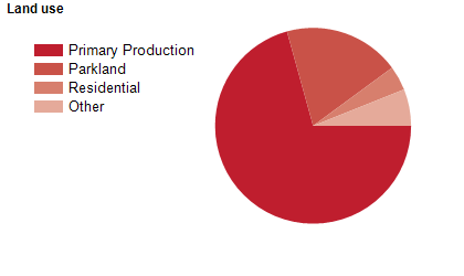
Land use
The G21 Region is a rural, residential and resort area, with some industrial and commercial land use. The Region encompasses a total land area of nearly 9,000 square kilometres, including significant areas of State Forest and National Park. Much of the rural area is used for timber-getting, farming, grazing, cropping, dairying, mining and viticulture. Tourism is an important industry, especially in the southern section along the Great Ocean Road and the Bellarine Peninsula. Geelong is the largest city and population centre in the G21 Region. Other major towns in the Region include Colac, the coastal towns of Anglesea, Apollo Bay, Lorne, Ocean Grove and Torquay, and the inland rural centres of Bannockburn and Winchelsea.
Transport
The G21 Region is served by the Princes Freeway, the Great Ocean Road, the Bellarine Highway, the Glenelg Highway, the Hamilton Highway, the Midland Highway, the Princes Highway, the Surf Coast Highway, Avalon Airport, Geelong Port, the Queenscliff-Sorrento Ferry and the Melbourne-Geelong-Warrnambool railway line.
Major features
- Major features of the G21 Region include Brisbane Ranges National Park,
- Great Otway National Park,
- Port Campbell National Park,
- Port Phillip Heads Marine National Park,
- You Yangs Regional Park,
- Enfield State Park,
- Steiglitz Historic Park,
- Lake Connewarre State Game Reserve,
- Barwon Bluff Marine Sanctuary,
- Erskine Falls,
- several other waterfalls,
- Otway Fly Treetop Adventures,
- The Great Ocean Road,
- Cape Otway Lightstation,
- Geelong Gallery,
- Geelong Performing Arts Centre,
- Old Geelong Gaol,
- National Wool Museum,
- Adventure Park Geelong,
- Tiger Moth World,
- Geelong Waterfront,
- The Geelong CBD,
- Westfield Geelong Shopping Centre,
- Market Square Shopping Centre,
- numerous wineries,
- Geelong Hospital,
- Fort Queenscliff,
- Queenscliff Harbour,
- Geelong Port,
- The Bellarine Railway,
- Queenscliff-Sorrento Ferry,
- Deakin University (Geelong Waterfront and Waurn Ponds Campuses),
- The Gordon Institute of TAFE (East Geelong and Geelong City Campuses and Colac Trade Training Centre),
- Marcus Oldham College,
- Kardinia Park,
- Jubilee Mine Historic Area,
- The Great Ocean Walk,
- Bells Beach,
- Eastern Beach and numerous other beaches.
Included areas
- The G21 Region includes five local government areas; Colac Otway Shire,
- Golden Plains Shire,
- The City of Greater Geelong,
- The Borough of Queenscliffe and Surf Coast Shire.