Fairfield City
About the profile areas
The 2023 Estimated Resident Population for Fairfield City is 209,742, with a population density of 2,066 persons per square km.
Location and boundaries
Fairfield City is located in Sydney's south western suburbs, about 32 kilometres from the Sydney GPO. Fairfield City is bounded by Blacktown City and the Cumberland Council area in the north, the City of Canterbury Bankstown in the east, Liverpool City in the south, and Penrith City in the west.
Traditional Owners
The original inhabitants of the Fairfield area were the Cabrogal Aboriginal people.
Name origin
Fairfield is named after the family estate of John Horsley (an original land holder) in Somerset, United Kingdom.
Important
|
Population209,742 2023 ABS ERP |
Land area101.5 square km |
Population density2,066 persons per square km |
Settlement history
European settlement dates from 1791, although population was minimal until the mid 1800s, spurred by the construction of the railway line in 1856. Land was used mainly for timber-cutting and crop farming, with some vineyards and orchards. Growth took place in the late 1800s, with a population of about 2,500 by the start of the 1900s. Expansion continued during the early 1900s, with the population growing to about 27,000 by 1948. Rapid growth took place in the post-war period, as many ex-service men and European migrants settled in the area, aided by a migrant camp at Cabramatta and large scale public housing estates. By 1979, the population had reached 120,000. Rapid growth continued during the 1980s, with growth slowing down during the early 1990s, reaching a population of 175,000 in 1991 and 181,000 in 1996. The population was relatively stable between 1996 and 2006, and then increased gradually to 198,000 in 2016.
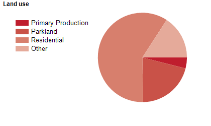
Land use
While mainly residential, the LGA contains six (6) industrial and business lands (829.8 hectares) which include large-scale industrial estates at Wetherill Park and Smithfield, as well as local industrial centres. Major commercial centres are located at Fairfield and Cabramatta. The City encompasses a total land area of approximately 104 square kilometres.
Transport
Major roads leading to Fairfield: are the Western Motorway (M4), The Hume Highway, The Cumberland Highway, The Western Sydney Orbital, South Western Motorway (M5), with various railway lines and bus services.
Major features
- Major features of Fairfield City include Western Sydney Parklands - agricultural based tourism and recreation,
- Chipping Norton Lakes - extensive waterways and recreation facilities,
- more than 450 parks incorporating a diverse range of recreational settings including children's play grounds,
- youth facilities,
- public art,
- picnic areas and landscape features,
- extensive network of cycleways,
- walking trails,
- sportsgrounds and bush parks,
- four major business and retail centres and a number of shopping centres,
- range of Cultural Cuisines,
- temples and public art at Fairfield Markets,
- and the Fairfield Showground - host to many large cultural and special large-scale events and capable of holding from 80 to 20,
- 000 people.
Included areas
- Fairfield City includes the suburbs and localities of Abbotsbury,
- Bonnyrigg,
- Bonnyrigg Heights,
- Bossley Park,
- Cabramatta,
- Cabramatta West,
- Canley Heights,
- Canley Vale,
- Carramar,
- Cecil Park (part),
- Edensor Park,
- Fairfield (part),
- Fairfield East,
- Fairfield Heights,
- Fairfield West,
- Greenfield Park,
- Horsley Park,
- Lansvale,
- Mount Pritchard (part),
- Old Guildford,
- Prairiewood,
- Smithfield (part),
- St Johns Park,
- Villawood (part),
- Wakeley,
- Wetherill Park and Yennora (part).