Eurobodalla Shire
About the profile areas
The 2023 Estimated Resident Population for Eurobodalla Shire is 40,912, with a population density of 11.94 persons per square km.
Location and boundaries
Eurobodalla Shire is located on the south coast of New South Wales, between 280 and 360 kilometres south of the Sydney CBD, and between 150 to 220 kilometres south-east of the Canberra CBD. Eurobodalla Shire is bounded by Shoalhaven City in the north, the Tasman Sea in the east, Bega Valley Shire and the Snowy Monaro Regional Council area in the south, and the Queanbeyan-Palerang Regional Council area in the west.
Traditional Owners
The original inhabitants of the Eurobodalla area were the Bugelli-Manji and Yuin Aboriginal people.
Name origin
Eurobodalla is named from an Aboriginal word meaning "small haven for boats" or "land between waters".
Important
|
Population40,912 2023 ABS ERP |
Land area3,428 square km |
Population density11.94 persons per square km |
Settlement history
European settlement dates from 1828, when land was settled on the north bank of the Moruya River. Growth was minimal until the 1850s, aided by gold discoveries, with Moruya becoming the centre of the Shire's development. More substantial growth took place in the late 1800s. Land was used mainly for grazing and dairy farming, with timber milling also being an important industry. Dairy farming remains one of the region's major industries. The most significant development occurred from the post-war years. The population of the Shire doubled during the 1980s and 1990s, growing from over 16,000 in 1981 to 33,000 in 2001. Growth continued between 2001 and 2011, with the population rising to over 35,000 in 2011. Recent growth has been in both rural areas and coastal townships.
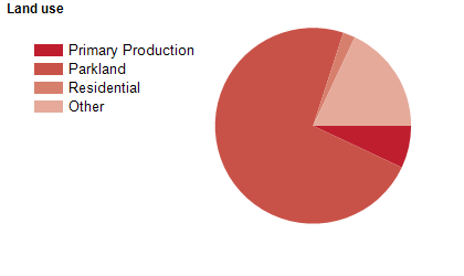
Land use
Eurobodalla Shire is a rural and growing residential and resort area. The main towns are Batemans Bay, Moruya and Narooma, with numerous other small villages. Most of the population is located along the coastal fringe, or living beside the lakes and rivers. The Shire encompasses a total land area of over 3,400 square kilometres, of which about three-quarters is national park or state forest. The major industries are timber production and dairy farming, including milk, butter and cheese production.
Transport
Eurobodalla Shire is served by the Princes Highway and the Kings Highway.
Major features
- Major features of the Shire include Budawang National Park,
- Clyde River National Park,
- Deua National Park,
- Eurobodalla National Park,
- Gulaga National Park,
- Monga National Park,
- Murramarang National Park,
- Wadbilliga National Park,
- various Nature Reserves (Broulee Island,
- Cullendulla,
- lllawong and Montague Island),
- several state forests,
- TAFE NSW Illawarra Institute (Moruya Campus),
- Central Tilba Historic Village,
- Birdland Animal Park,
- Mogo Zoo,
- The Original Gold Rush Colony,
- Mount Dromedary and various rivers,
- lakes,
- islands and beaches.
Included areas
- Eurobodalla Shire includes the townships and localities of Akolele,
- Batehaven,
- Batemans Bay,
- Belowra,
- Benandarah,
- Bergalia,
- Bimbimbie,
- Bingie,
- Bodalla,
- Broulee,
- Buckenbowra,
- Cadgee,
- Catalina,
- Central Tilba,
- Coila,
- Congo,
- Corunna,
- Currowan (part),
- Dalmeny,
- Denhams Beach,
- Deua,
- Deua River Valley,
- Dignams Creek (part),
- East Lynne (part),
- Eurobodalla,
- Guerilla Bay,
- Jeremadra,
- Kianga,
- Kiora,
- Lilli Pilli,
- Long Beach,
- Maloneys Beach,
- Malua Bay,
- Meringo,
- Merricumbene,
- Mogendoura,
- Mogo,
- Moruya,
- Moruya Heads,
- Mossy Point,
- Murrengenburg,
- Mystery Bay,
- Narooma,
- Nelligen,
- Neringla (part),
- Nerrigundah,
- North Batemans Bay,
- North Narooma,
- Potato Point,
- Rosedale,
- Runnyford,
- South Durras,
- Sunshine Bay,
- Surf Beach,
- Surfside,
- Tilba Tilba,
- Tinpot (part),
- Tomakin,
- Turlinjah,
- Tuross Head,
- Wamban,
- Woodlands and Yowrie (part).