Cumberland City
About the profile areas
The 2023 Estimated Resident Population for Cumberland City is 245,323, with a population density of 3,371 persons per square km.
Location and boundaries
The Cumberland Council area is located in Sydney's western suburbs, about 25 kilometres from the Sydney CBD. The Cumberland Council area is bounded by the City of Parramatta in the north, the Strathfield Council area in the east, the City of Canterbury Bankstown and Fairfield City in the south, and Blacktown City in the west.
Traditional Owners
The original inhabitants of the Cumberland Council area were the Dharug Aboriginal people.
Important
|
Population245,323 2023 ABS ERP |
Land area72.77 square km |
Population density3,371 persons per square km |
Settlement history
European settlement dates from the 1790s when expansion from Parramatta stimulated growth in the northern suburbs. Land was used mainly for small scale farming and sheep and cattle grazing. Population was minimal until the 1850s and 1860s. Growth took place during the late 1870s and 1880s, aided by the opening of railway lines and the establishment of many industries. The population continued to grow in the early 1900s. The most significant residential development occurred in the post-war years, particularly during the 1950s and 1960s, aided by immigration and industrial growth. Gradual growth took place from the 1990s, with the population of the Council area rising from about 153,000 in 1991 to about 215,000 in 2016. Most of the growth in the last twenty five years has been from urban consolidation (medium and high density housing) in the established areas, but more recently has also been from redevelopment of previous industrial land in the suburbs of Pemulwuy and Regents Park.
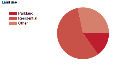
Land use
The Cumberland Council area is predominantly residential, with substantial industrial areas, and some commercial, institutional and recreational areas. The Council area encompasses a total land area of about 70 square kilometres.
Transport
The Cumberland Council area is served by the Western Motorway, the Cumberland Highway, the Great Western Highway and the Bankstown, Cumberland and Western railway lines.
Major features
- Major features of the Council area include Carnarvon Golf Club,
- Cumberland Country Golf Club,
- Rosnay Golf Club (Auburn Public Golf Course),
- Woodville Golf Course,
- Auburn Central Shopping Centre,
- Auburn Arcade Shopping Centre,
- Primewest Auburn Megamall,
- The Merrylands CBD,
- Stockland Merrylands Shopping Centre,
- Wentworthville Mall,
- Wentworthville Shopping Plaza,
- part of Granville Town Centre,
- TAFE NSW South Western Sydney Institute (Granville and Lidcombe Colleges),
- The University of Sydney (Cumberland Campus),
- Auburn Athletics Track,
- Melita Stadium,
- Auburn Botanic Gardens,
- Campbell Hill Pioneer Reserve,
- Central Gardens,
- Granville Park,
- Holroyd Gardens,
- Merrylands Park,
- Wyatt Park and Rookwood Necropolis (Cemetery).
Included areas
- The Cumberland Council area includes the suburbs of Auburn (part),
- Berala,
- Chester Hill (part),
- Fairfield (part),
- Girraween,
- Granville (part),
- Greystanes,
- Guildford,
- Guildford West,
- Holroyd,
- Homebush West (part),
- Lidcombe (part),
- Mays Hill (part),
- Merrylands,
- Merrylands West,
- Pemulwuy,
- Pendle Hill (part),
- Prospect (part),
- Regents Park (part),
- Rookwood,
- Smithfield (part),
- South Granville,
- South Wentworthville,
- Toongabbie (part),
- Wentworthville (part),
- Westmead (part),
- Woodpark and Yennora (part).