Cessnock City
About the profile areas
The 2023 Estimated Resident Population for Cessnock City is 67,591, with a population density of 34.38 persons per square km.
Location and boundaries
Cessnock City is located in the Hunter Valley, New South Wales, about 120 kilometres north of Sydney and 40 kilometres west of Newcastle. Cessnock City is bounded by Maitland City in the north, the City of Newcastle and Lake Macquarie City in the east, the Central Coast Council area and Hawkesbury City in the south and the Singleton Council area in the west.
Traditional Owners
The Cessnock local government area is largely made up of the traditional lands of the Wonnarua people.
Name origin
Cessnock is named after Cessnock castle in Ayrshire, Scotland.
Important
|
Population67,591 2023 ABS ERP |
Land area1,966 square km |
Population density34.38 persons per square km |
Settlement history
European settlement dates from the 1820s when pastoralists arrived, using land mainly for farming, market gardening and timber getting. The Great North Road was constructed in the 1830s, linking the Hawkesbury and Hunter Valleys. Wollombi was the centre of the area till the late 1800s. The township of Branxton emerged from 1848, spurred by its accessibility to water, rich agricultural land and location as a road junction. The township of Cessnock developed from 1850 as a service centre at the junction of the Great North Road. There was some growth in the 1850s and 1860s with wheat, tobacco and grapes being grown, especially around Cessnock, Nulkaba and Pokolbin. Significant development in Cessnock occurred when coal was struck in 1892 and several coal mines were established. This generated extensive land settlement between 1903 and 1923, with townships established near the pit tops and rail heads of the coal seam. Townships included Aberdare, Abermain, Abernethy, Bellbird, Heddon Greta, Kearsley, Kitchener, Kurri Kurri, Neath, Pelaw Main, Stanford Merthyr and Weston. By 1926 Cessnock had a population of 12,000, increasing to 18,000 by the 1940s. Other than coal mining, Cessnock's industries at this time included dairying, grazing, timber getting, saw-milling and manufacturing of earthenware pipes and textiles. Substantial development occurred in the post-war years. Until the 1960s mining was the principal industrial base and source of employment in the Cessnock area. Changes to the mining industry led to the closure of the vast majority of mines, resulting in a decline in population in many villages and townships, especially from the 1980s. Many areas have undergone a change in character, with rural-residential housing developments becoming popular. There has been a rise in the wine and tourism industry, with many vineyards at Allandale, Mount View, Pokolbin, and Rothbury, as well as small cottages and farms used mainly as weekend retreats. Since the early 1990s the population in the City has grown, rising from nearly 44,000 in 1991 to nearly 51,000 in 2011. Growth was most significant between 2006 and 2011. Much of the recent growth has been in the rural settlements and villages, including Blackhill, Buchanan, Ellalong, Greta, Heddon Greta, Laguna, Millfield, North Rothbury, Pokolbin, Quorrobolong and Richmond Vale.
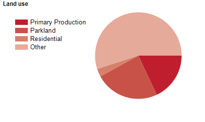
Land use
Cessnock City is a rural and residential area. The City encompasses a total land area of 1,950 square kilometres, of which a large proportion is State Forest and National Park. Most of the rural area is used for grazing, farming, timber-getting and viticulture. The City has two main townships, Cessnock and Kurri Kurri, with much of the population concentrated in a narrow urban belt between these.
Transport
Cessnock City is served by the New England Highway.
Major features
- Major features of the City include Watagans National Park,
- Werakata National Park,
- Yengo National Park,
- TAFE NSW Hunter Institute (Cessnock and Kurri Kurri Campuses),
- Cessnock District Hospital,
- Cessnock City Centre,
- Cessnock Racecourse,
- Koolang Astronomical Observatory,
- Richmond Vale Railway Museum,
- Cessnock Performing Arts Centre,
- Cessnock Regional Art Gallery,
- Kurri Kurri Regional Museum,
- Hunter Valley Zoo,
- Hunter Valley Chocolate Company,
- various state forests and over 100 vineyards and wineries based around the Pokolbin area.
Included areas
- Cessnock City includes the towns and localities of Aberdare,
- Abermain,
- Abernethy,
- Allandale (part),
- Bellbird,
- Bellbird Heights,
- Big Yengo,
- Bishops Bridge (part),
- Black Hill (part),
- Branxton (part),
- Brunkerville,
- Buchanan,
- Bucketty (part),
- Buttai,
- Cedar Creek,
- Cessnock,
- Cliftleigh (part),
- Congewai,
- Corrabare,
- East Branxton,
- Ellalong,
- Elrington,
- Four Mile Creek,
- Greta,
- Greta Main,
- Heddon Greta,
- Kearsley,
- Keinbah,
- Kitchener,
- Kurri Kurri,
- Laguna,
- Lochinvar (part),
- Lovedale,
- Loxford,
- Millfield,
- Moruben,
- Mount View,
- Mount Vincent,
- Mulbring,
- Neath,
- North Rothbury,
- Nulkaba,
- Olney,
- Paxton,
- Paynes Crossing (part),
- Pelaw Main,
- Pelton,
- Pokolbin (part),
- Quorrobolong,
- Richmond Vale,
- Rothbury,
- Sawyers Gully,
- Stanford Merthyr,
- Stockrington,
- Sweetmans Creek,
- Weston and Wollombi.