Campaspe Shire
About the profile areas
The 2023 Estimated Resident Population for Campaspe Shire is 38,299, with a population density of 8.47 persons per square km.
Location and boundaries
Campaspe Shire is located in north-central Victoria, about 180 kilometres north of the Melbourne CBD. Campaspe Shire is bounded by the Murray River and the New South Wales border in the north, Moira Shire in the north-east, the City of Greater Shepparton in the east, Strathbogie Shire and the City of Greater Bendigo in the south, Loddon Shire in the west, and Gannawarra Shire in the north-west.
Traditional Owners
The original inhabitants of Campaspe Shire were the Yorta Yorta, Dja Dja Wurrung and Taungurung Aboriginal people.
Name origin
Campaspe Shire is named after the Campaspe River, which was named by Major Mitchell in 1836 after Alexander the Great's concubine.
Important
|
Population38,299 2023 ABS ERP |
Land area4,519 square km |
Population density8.47 persons per square km |
Settlement history
European settlement dates from the 1840s, with land used mainly for farming, particularly sheep grazing. Significant development took place in the late 1800s, when several townships were established, access was improved, dairy farming and orcharding were established and river trade at Echuca boomed. The Port of Echuca became the largest inland port in Australia, with paddle steamers bringing wool, wheat and timber to the railhead at Echuca, for eventual sale and shipping overseas. River trade began to decline from the 1890s as railways were extended and road transport improved. Population growth resumed during the interwar period. The population gradually increased from the post-war years. The population continued to increase gradually from the 1990s, with most of this growth in Echuca.
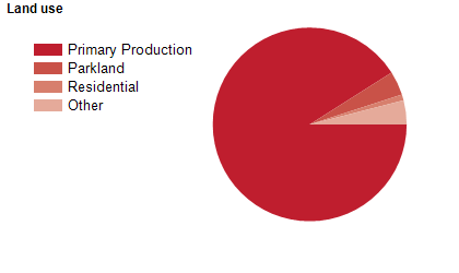
Land use
Campaspe Shire is a predominantly rural area, but has significant residential areas in the townships of Echuca and Kyabram. The largest town is Echuca, followed by Kyabram. Smaller townships include Gunbower, Lockington, Rochester, Rushworth, Stanhope and Tongala. The Shire encompasses a total land area of about 4,500 square kilometres. Land is used mainly for agriculture, particularly dairy farming, cereal and grain growing and sheep grazing. Tourism is also an important industry.
Transport
Campaspe Shire is served by the Midland Highway, the Murray Valley Highway, the Northern Highway, the Melbourne-Bendigo-Echuca railway line and Echuca Aerodrome.
Major features
- Major features of the Shire include the Campaspe,
- Murray and Goulburn Rivers,
- The Port of Echuca,
- Echuca Paddlesteamers & River Cruises,
- Port of Echuca Discovery Centre,
- National Holden Motor Museum,
- Kyabram Fauna Park,
- Rochester Sports Museum,
- The Great Aussie Beer Shed & Heritage Farm Museum,
- Whroo Historic Reserve (including the Balaclava open cut mine),
- Lockington & District Living Heritage Complex,
- Bendigo TAFE (Echuca Campus),
- Torrumbarry Weir,
- Waranga Basin,
- Lake Cooper,
- Gunbower Island,
- Wallenjoe Wetlands,
- several state forests and various wineries.
Included areas
- Campaspe Shire includes the localities of Ballendella,
- Bamawm,
- Bamawm Extension,
- Bonn,
- Burnewang,
- Burramboot,
- Carag Carag,
- Colbinabbin,
- Cornella,
- Corop,
- Creek View,
- Diggora,
- Echuca,
- Echuca Village,
- Echuca West,
- Fairy Dell,
- Girgarre,
- Gobarup,
- Gunbower,
- Kanyapella,
- Kotta,
- Koyuga,
- Ky Valley,
- Kyabram (part),
- Lancaster (part),
- Lockington,
- Milloo (part),
- Mitiamo (part),
- Moora,
- Muskerry,
- Myola,
- Nanneella,
- Patho,
- Pine Grove,
- Redcastle (part),
- Rochester,
- Roslynmead,
- Runnymede,
- Rushworth,
- Stanhope,
- Strathallan,
- Tennyson,
- Terrick Terrick East,
- Timmering,
- Tongala,
- Toolleen (part),
- Torrumbarry,
- Wanalta,
- Waranga Shores,
- Wharparilla,
- Whroo (part),
- Wyuna,
- Wyuna West and Yambuna.