Burwood Council area
About the profile areas
The 2023 Estimated Resident Population for Burwood Council area is 42,498, with a population density of 5,960 persons per square km.
Location and boundaries
The Burwood Council area is located in the inner-western suburbs of Sydney, about 12 kilometres west of the Sydney GPO. The Burwood Council area is bounded by the City of Canada Bay in the north, the Inner West Council area in the east, the City of Canterbury Bankstown in the south, and the Strathfield Council area in the west. Burwood Council area's boundaries are Parramatta Road in the north, Lang Street, Queen Street, Dickinson Avenue, Liverpool Road and Greenhills Street in the east, Georges River Road, Burwood Road and the Cooks River in the south, and Coronation Parade, The Boulevarde and Mosely Street in the west.
Traditional Owners
The original inhabitants of the Burwood area were the Wangal Aboriginal people.
Name origin
Burwood is named after an early property in the area, which was named after a place in Cornwall, England.
Important
|
Population42,498 2023 ABS ERP |
Land area7.13 square km |
Population density5,960 persons per square km |
Settlement history
European settlement dates from 1793 when the first land grant was made. Land was used mainly for farming and timber-getting. Population was minimal until the 1830s when land was subdivided and a village was established. Growth took place in the 1850s, spurred by the opening of the Sydney-Parramatta railway line. More substantial growth took place during the 1870s and 1880s. By 1900 the population had reached about 7,400. Expansion continued during the early 1900s, with the population increasing to over 20,000 by 1930. Significant development occurred during the post-war years, when many apartments were built. The population increased from about 21,000 in 1961 to nearly 32,000 in 1966. During the early 1970s the population began to decline, falling to about 29,000 by 1976. The population stabilised from the mid 1970s to the mid 1990s. From the mid 1990s the population increased gradually, rising from about 28,000 in 1996 to over 32,000 in 2011.
Land use
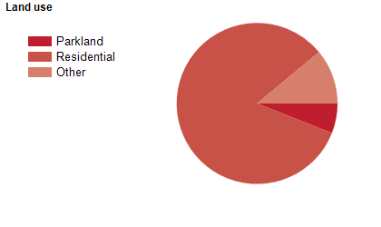
The Burwood Council area is a predominantly residential area, with significant commercial areas. The Council area encompasses a total land area of about 7 square kilometres.
Transport
The Burwood Council area is served by Parramatta Road, Liverpool Road (Hume Highway) and the inner west railway line.
Major features
- Major features of the Council area include the Burwood Town Centre,
- Westfield Burwood Shopping Centre,
- Burwood Park,
- Henley Park,
- Enfield Aquatic Centre and the Cooks River.
Included areas
- The Burwood Council area includes the suburbs of Burwood,
- Burwood Heights,
- Croydon (part),
- Croydon Park (part),
- Enfield and Strathfield (part).

