City of Boroondara
About the profile areas
The 2023 Estimated Resident Population for the City of Boroondara is 174,537, with a population density of 2,901 persons per square km.
Location and boundaries
The City of Boroondara is located in the inner eastern suburbs of Melbourne, between 5 and 10 kilometres east of the Melbourne CBD. The City of Boroondara is bounded by the City of Banyule and the Manningham City Council area in the north, the City of Whitehorse and the City of Monash in the east, the City of Stonnington in the south, and the City of Yarra in the west. The City of Boroondara's boundaries are the Yarra River and Koonung Creek in the north, Sweyn Street, Winfield Road, Evelina Street, Kerry Parade, Kinsale Crescent, Carrick Street, Carlyle Crescent, Barloa Road, York Street, Wilson Street, Windsor Crescent, Alexandra Crescent, Canterbury Road and Warrigal Road in the east, Gardiners Creek in the south, and the Yarra River in the west.
Traditional Owners
The original inhabitants of the City of Boroondara were the Wurundjeri Woi-wurrung people.
Name origin
The City of Boroondara's name is derived from the Woi-wurrung language meaning "where the ground is thickly shaded".
Important
|
Population174,537 2023 ABS ERP |
Land area60.17 square km |
Population density2,901 persons per square km |
Settlement history
European settlement dates from 1837. Growth was minimal until the 1850s, when the development of Hawthorn began. Development in Kew also began around this time, while the remainder of Boroondara was developed as the railway and tramlines were extended east. Significant residential and commercial development took place in the late 1800s. Expansion continued during the interwar and post-war periods. The population of the City has gradually increased since the 1990s.
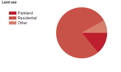
Land use
The City of Boroondara is a predominantly residential area, with some commercial and educational land use. The City encompasses a total land area of about 60 square kilometres.
Transport
The City of Boroondara is served by the Eastern Freeway, the Monash Freeway, Citylink, the Alamein, Belgrave and Lilydale railway lines, and a number of tramlines.
Major features
- Major features of the City of Boroondara include Swinburne University of Technology (Hawthorn Campus),
- The Camberwell Junction shopping area,
- The Glenferrie Road shopping area (Hawthorn),
- The Kew Junction shopping area,
- Studley Park,
- Yarra Bend Park,
- numerous other parks,
- gardens and golf courses,
- Melbourne Tram Museum,
- The Outer Circle Trail,
- The Yarra River,
- and various private schools and small hospitals.
Included areas
- The City of Boroondara includes the suburbs of Ashburton,
- Balwyn,
- Balwyn North (part),
- Camberwell,
- Canterbury,
- Deepdene,
- Glen Iris (part),
- Hawthorn,
- Hawthorn East,
- Kew,
- Kew East,
- Mont Albert (part) and Surrey Hills (part).