City of Bayside
About the profile areas
The 2023 Estimated Resident Population for the City of Bayside is 104,272, with a population density of 2,804 persons per square km.
Location and boundaries
The City of Bayside is located in Melbourne's middle-southern suburbs, between 8 and 20 kilometres south of the Melbourne CBD. The City of Bayside is bounded by the City of Port Phillip and the City of Glen Eira in the north, the City of Kingston in the east, and the Port Phillip Bay foreshore in the south and west. The City of Bayside's boundaries are Head Street, St Kilda Street and Glen Huntly Road in the north, and the Nepean Highway, North Road, Thomas Street, the Frankston railway line and Charman Road in the east.
Traditional Owners
The original inhabitants of the City of Bayside were the Boon wurrung Aboriginal people.
Important
|
Population104,272 2023 ABS ERP |
Land area37.19 square km |
Population density2,804 persons per square km |
Settlement history
European settlement dates from 1841 when Henry Dendy purchased his 'special survey' area from the government. The special survey area covered modern day Brighton, Brighton East, Bentleigh and McKinnon. The Brighton area was subdivided and sold in the 1850s, with growth from the 1860s, spurred by the opening of railway lines. Development of areas further south along the coastline followed in the late 1800s, aided by improved access. Substantial growth took place during the interwar and post-war periods, with areas furthest from the railway line such as Brighton East and Beaumaris characterised by post-war housing development. The population of the City increased gradually from the 1990s.
Land use
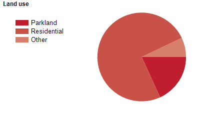
The City of Bayside is predominantly a residential area, with some small commercial and industrial areas. The City encompasses a total land area of about 37 square kilometres.
Transport
The City of Bayside is served by the Nepean Highway and the Sandringham and Frankston railway lines.
Major features
- Major features of the City of Bayside include the Port Phillip Bay foreshore,
- numerous beaches (Beaumaris,
- Black Rock,
- Dendy Street,
- Hampton,
- Middle Brighton,
- Sandringham and Seacombe Grove),
- Middle Brighton Baths,
- Cheltenham Park,
- Dendy Park,
- Elsternwick Park,
- several major golf clubs (Brighton,
- Cheltenham,
- Royal Melbourne,
- Sandringham and Victoria),
- various yacht clubs (Beaumaris,
- Black Rock,
- Hampton,
- Royal Brighton and Sandringham),
- Sandringham Hospital,
- Cabrini Hospital Brighton,
- Epworth Brighton Rehabilitation Centre,
- Linacre Private Hospital,
- major shopping strips along Bay Road (Sandringham),
- Bay Street (North Brighton),
- Church Street (Middle Brighton),
- Hampton Street (Hampton) and Martin Street (Gardenvale),
- The Beaumaris Concourse retail area,
- Black Rock Shopping Centre,
- Highett Shopping Centre,
- Ricketts Point Marine Sanctuary and HMVS Cerberus.
Included areas
- The City of Bayside encompasses the suburbs of Beaumaris,
- Black Rock,
- Brighton,
- Brighton East,
- Cheltenham (part),
- Hampton,
- Hampton East,
- Highett (part) and Sandringham.

