Bass Coast Shire
About the profile areas
The 2023 Estimated Resident Population for Bass Coast Shire is 42,729, with a population density of 49.45 persons per square km.
Location and boundaries
Bass Coast Shire is located in south-eastern Victoria, about 130 kilometres south-east of the Melbourne CBD. Bass Coast Shire is bounded by Western Port Bay in the north and west, Cardinia Shire in the north-east, South Gippsland Shire in the east, and Bass Strait in the south.
Traditional Owners
The original inhabitants of Bass Coast Shire were the Bunurong Aboriginal people.
Name origin
Bass Coast Shire is named after the Bass Coast, which is named after the explorer George Bass.
Important
|
Population42,729 2023 ABS ERP |
Land area864.1 square km |
Population density49.45 persons per square km |
Settlement history
European settlement dates from 1826 when a military outpost was set up at a Corinella. However, permanent settlement did not occur until the late 1830s, with land used mainly for timber-getting, farming and grazing. Population was minimal until the 1860s when land was opened for selection, with growth particularly around Wonthaggi, largely due to coal mining. Growth took place from the late 1800s into the early 1900s, when many townships and villages were established. Significant development occurred from the post-war years, including growth on Phillip Island, spurred by the construction of the first bridge in the 1940s. Growth continued during the 1970s and the 1980s, with increases in both permanent and holiday homes. Expansion continued from the 1990s.
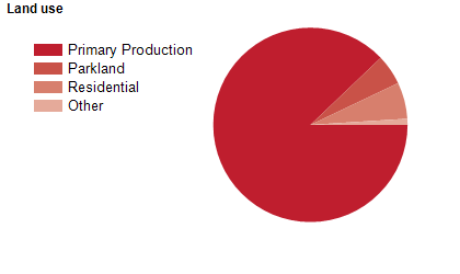
Land use
Bass Coast Shire is a rural, residential and holiday area. The Shire encompasses a total land area of about 860 square kilometres, including substantial coastal areas. The major towns are Wonthaggi, Cowes, Inverloch, San Remo and Grantville, with numerous smaller townships. The major industries of the Shire are tourism and agriculture, particularly cattle and sheep grazing.
Transport
Bass Coast Shire is served by the Bass Highway and the South Gippsland Highway.
Major features
- Major features of Bass Coast Shire include Phillip Island,
- Churchill Island,
- The Nobbies,
- Seal Rocks,
- Phillip Island Penguin Parade,
- Phillip Island Grand Prix Circuit,
- The Nobbies Centre,
- Amaze ‘N Things,
- Churchill Island Heritage Farm,
- Phillip Island Wildlife Park,
- Maru Koala & Animal Park,
- Koala Conservation Centre,
- Mutton Bird Colony & Rookeries,
- Wonthaggi State Coal Mine Heritage Area,
- National Vietnam Veterans Museum,
- Chisholm Institute of TAFE (Bass Coast Campus),
- Phillip Island Golf Club,
- The Golf Club Bass Coast,
- Wonthaggi Golf Club,
- Wonthaggi Hospital,
- Bunurong Marine National Park,
- Churchill Island Marine National Park,
- Grantville Nature Conservation Reserve,
- The Gurdies Nature Conservation Reserve,
- Scenic Estate Conservation Reserve,
- Cape Woolamai State Faunal Reserve,
- George Bass Coastal Walk,
- Bass Coast Rail Trail,
- several wineries and numerous beaches.
Included areas
- Bass Coast Shire includes the localities of Adams Estate,
- Almurta,
- Anderson,
- Archies Creek,
- Bass,
- Cape Paterson,
- Cape Woolamai,
- Churchill Island,
- Corinella,
- Coronet Bay,
- Cowes,
- Dalyston,
- Glen Alvie,
- Glen Forbes,
- Grantville,
- Harmers Haven,
- Inverloch (part),
- Jam Jerrup,
- Kernot,
- Kilcunda,
- Kongwak (part),
- Krowera (part),
- Lance Creek,
- Lang Lang (part),
- Loch (part),
- Newhaven,
- North Wonthaggi,
- Outtrim (part),
- Pioneer Bay,
- Pound Creek (part),
- Queensferry,
- Rhyll,
- Ryanston,
- San Remo,
- Silverleaves,
- Smiths Beach,
- South Dudley,
- St Clair,
- Summerlands,
- Sunderland Bay,
- Sunset Strip,
- Surf Beach,
- Tenby Point,
- The Gurdies,
- Ventnor,
- Wattle Bank,
- West Creek,
- Wimbledon Heights,
- Wonthaggi,
- Woodleigh and Woolamai.