The Barossa Council area
About the profile areas
The 2023 Estimated Resident Population for The Barossa Council area is 26,268, with a population density of 29.41 persons per square km.
Location and boundaries
The Barossa Council area is located to the north-east of metropolitan Adelaide, between 50 and 60 kilometres from the Adelaide CBD. The Barossa Council area is bounded by the Light Regional Council area in the north, the Mid Murray Council area in the east, the Adelaide Hills Council area in the south, and the City of Playford and the Town of Gawler in the west.
Traditional Owners
The original inhabitants of the Barossa Council area were the Peramangk and Ngadjuri Aboriginal people.
Name origin
Barossa Council is named after the Barossa Ranges, which were named by Colonel William Light, South Australia's first Surveyor General, after Barrosa in Spain, the battle site of the Peninsular War.
Important
|
Population26,268 2023 ABS ERP |
Land area893.2 square km |
Population density29.41 persons per square km |
Settlement history
European settlement of the area dates from the late 1830s. The townships of Angaston, Eden Valley, Krondorf, Light Pass, Lyndoch, Mount Pleasant, Nuriootpa, Penrice, Rosedale, Rowland Flat, Springton, Stockwell, Tanunda and Williamstown were established in the 1840s and 1850s. Land was used mainly for farming, particularly sheep grazing and crop growing. Expansion occurred from the 1880s into the early 1900s, with the area becoming a major wine producer. Development continued from the post-war years. The population increased gradually from the early 1990s, rising from about 16,000 in 1991 to about 23,000 in 2016.
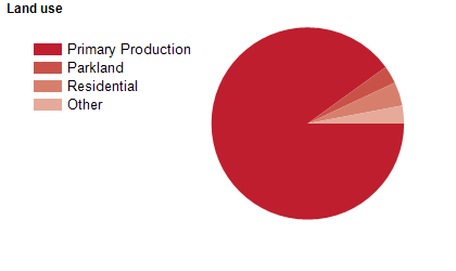
Land use
The Barossa Council area is predominantly rural, with substantial rural-residential and township areas. The Council area encompasses a total land area of over 900 square kilometres. The major townships include Angaston, Lyndoch, Mount Pleasant, Nuriootpa, Tanunda and Williamstown. Rural land is used mainly for sheep and cattle grazing, crop and fruit growing and viticulture. Tourism is also an important industry, with Barossa being one of Australia's renowned wine regions.
Transport
The Barossa Council area is served by the Barossa Valley Highway and the Sturt Highway.
Major features
- Major features of the Council area include Hale Conservation Park,
- Kaiserstuhl Conservation Park,
- Parra Wirra Conservation Park,
- Sandy Creek Conservation Park,
- Barossa Reservoir,
- South Para Reservoir,
- Warren Reservoir,
- Barossa Bushgardens,
- TAFE SA (Barossa Nuriootpa Campus),
- Angaston District Hospital,
- Mount Pleasant District Hospital,
- Tanunda War Memorial Hospital,
- The Barossa Museum,
- Barossa Regional Gallery,
- The Rex (Barossa Aquatic & Fitness Centre),
- The Heysen Trail and numerous wineries.
Included areas
- The Barossa Council area includes the localities of Altona,
- Angaston,
- Barossa Goldfields,
- Bethany,
- Cockatoo Valley,
- Concordia,
- Cromer (part),
- Eden Valley (part),
- Flaxman Valley,
- Kalbeeba,
- Krondorf,
- Light Pass,
- Lyndoch (part),
- Moculta,
- Mount Crawford (part),
- Mount McKenzie,
- Mount Pleasant (part),
- Nuriootpa (part),
- Penrice,
- Pewsey Vale,
- Rosedale (part),
- Rowland Flat (part),
- Sandy Creek,
- Springton (part),
- Stockwell (part),
- Tanunda (part),
- Taunton,
- Truro (part),
- Vine Vale and Williamstown.