City of Banyule
About the profile areas
The 2023 Estimated Resident Population for the City of Banyule is 129,602, with a population density of 2,073 persons per square km.
Location and boundaries
The City of Banyule is located in Melbourne's north-eastern suburbs, between 7 and 21 kilometres from the Melbourne CBD. The City of Banyule is bounded by Nillumbik Shire in the north and north-east, the Manningham City Council area in the south-east, the City of Boroondara and the City of Yarra in the south, and Darebin City and the City of Whittlesea in the west. The City of Banyule’s boundaries are the Metropolitan Ring Road, the Greensborough Bypass and its proposed extension in the north, Ryans Road, Progress Road, Weidlich Road, Karingal Drive, Sherbourne Road, Bolton Street and Fitzsimons Lane in the east, the Yarra River in the south, and Darebin Creek, Crissane Road, Kingsbury Drive, Waiora Road, Cherry Street, Broadford Crescent, Highview Crescent, Gresswell Forest Nature Conservation Reserve, Bendoran Crescent, Moreton Crescent and Plenty Road in the west.
Traditional Owners
The original inhabitants of the City of Banyule were the Wurundjeri Willam Aboriginal people.
Name origin
The City of Banyule is named from an Aboriginal word meaning "hill".
Important
|
Population129,602 2023 ABS ERP |
Land area62.51 square km |
Population density2,073 persons per square km |
Settlement history
European settlement dates from 1837 when land was surveyed. Some growth took place in the 1840s and 1850s, with the earliest areas of settlement being Heidelberg and Ivanhoe. Land was used mainly for farming and sheep and cattle grazing, with several small townships established. Expansion took place in the early 1900s, particularly during the 1920s. The construction of the railway to Hurstbridge encouraged the development of areas such as Eaglemont and Rosanna. Significant development occurred in the post-war years, when suburbs such as Macleod, Watsonia, Greensborough and Heidelberg West expanded. The population of the City fluctuated slightly during the 1990s, and then increased gradually in more recent years.
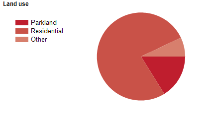
Land use
The City of Banyule is a predominantly residential area, with significant open spaces and parklands. The City encompasses a total land area of 63 square kilometres.
Transport
The City of Banyule is served by the Greensborough Highway, the Metropolitan Ring Road, the Greensborough Bypass, Plenty Road and the Hurstbridge railway line.
Major features
- Major features of the City of Banyule include Simpson Army Barracks,
- Austin Hospital,
- Mercy Hospital for Women,
- Heidelberg Repatriation Hospital,
- Melbourne Polytechnic (Heidelberg Campus),
- Greensborough Plaza (shopping centre),
- Warringal Shopping Centre,
- WaterMarc Aquatic & Leisure Centre,
- Nets Stadium Banyule,
- Yarra Flats Park,
- Banyule Flats Reserve,
- Darebin Creek Parklands,
- Warringal Parklands,
- Chelsworth Park,
- Wilson Reserve,
- The Plenty River,
- The Yarra River,
- various golf clubs and the Heidelberg School Artists Trail.
Included areas
- The City of Banyule includes the suburbs of Bellfield,
- Briar Hill,
- Bundoora (part),
- Eaglemont,
- Eltham North (part),
- Greensborough (part),
- Heidelberg,
- Heidelberg Heights,
- Heidelberg West,
- Ivanhoe,
- Ivanhoe East,
- Lower Plenty,
- Macleod (part),
- Montmorency,
- Rosanna,
- St Helena,
- Viewbank,
- Watsonia,
- Watsonia North and Yallambie.