Ballina Shire
About the profile areas
The 2023 Estimated Resident Population for Ballina Shire is 47,279, with a population density of 97.36 persons per square km.
Location and boundaries
Ballina Shire is located on the Far North Coast of New South Wales, about 770 kilometres north of Sydney and 190 kilometres south of Brisbane. Ballina Shire is bounded by Skinners Creek and Byron Shire in the north, the Coral Sea in the east, the Richmond River and the Richmond Valley Council area in the south, and Lismore City in the west.
Traditional Owners
The original inhabitants of the Ballina area were the Bundjalung Aboriginal people.
Name origin
Ballina is thought to be named either from Aboriginal words meaning "place of fish and oysters" or "fighting ground", or after a town in Ireland.
Important
|
Population47,279 2023 ABS ERP |
Land area485.6 square km |
Population density97.36 persons per square km |
Settlement history
European settlement dates from 1842, with land used mainly for timber-getting and agriculture. From the 1860s, land was used more for sugar cane growing, maize growing and dairy farming. Gradual growth took place during the late 1800s. Significant development occurred from the post-war years, with the population increasing from about 8,000 in 1947 to about 9,000 in 1966. Rapid growth took place during the 1970s and 1980s. The population increased from under 11,000 in 1971 to 19,000 in 1981, and then to 30,000 in 1991. The population continued to increase from the 1990s, rising to over 39,000 in 2011, with growth slowing between 2006 and 2011.
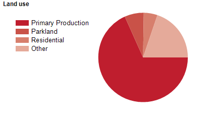
Land use
Ballina Shire is a rural area, with increasing urban land use in many towns and villages. The main townships are Alstonville, Ballina, Lennox Head, Wardell and Wollongbar. Ballina township is the main centre. The Shire encompasses a total land area of over 480 square kilometres, including significant areas of coastline. Rural land is used largely for grazing, and fruit and nut growing.
Transport
Ballina Shire is served by the Bruxner Highway, the Pacific Highway and Ballina Byron Gateway Airport.
Major features
- Major features of the Shire include Ballina Nature Reserve,
- Davis Scrub Nature Reserve,
- Little Pimlico Island Nature Reserve,
- Richmond River Nature Reserve,
- Tuckean Nature Reserve,
- Uralba Nature Reserve,
- Victoria Park Nature Reserve,
- North Coast TAFE (Ballina and Wollongbar Campuses),
- The Ballina CBD,
- Ballina Fair Shopping Centre,
- Ballina District Hospital,
- Ballina Racecourse,
- Richmond River Cruises,
- Amaze 'n' Place,
- Ballina Naval & Maritime Museum,
- Crawford House Museum,
- Summerland House Farm,
- The Macadamia Castle,
- Thursday Plantation,
- Ballina Golf Club,
- Teven Valley Golf Course,
- Alstonville Leisure & Entertainment Centre,
- Alstonville Heated Olympic Pool,
- Ballina Memorial Olympic Pool,
- Lake Ainsworth Sport and Recreation Centre,
- Lennox Head Aquatic Centre,
- The Richmond River and various beaches.
Included areas
- Ballina Shire includes the townships and localities of Alstonvale,
- Alstonville,
- Bagotville,
- Ballina,
- Broken Head (part),
- Brooklet,
- Cabbage Tree Island,
- Coolgardie,
- Cumbalum,
- Dalwood,
- East Ballina,
- East Wardell,
- Empire Vale,
- Fernleigh,
- Goat Island,
- Keith Hall,
- Knockrow,
- Lennox Head,
- Lynwood,
- Marom Creek (part),
- Mcleans Ridges (part),
- Meerschaum Vale,
- Newrybar (part),
- Patchs Beach,
- Pearces Creek (part),
- Pimlico,
- Pimlico Island,
- Rous,
- Rous Mill,
- Skennars Head,
- South Ballina,
- Teven,
- Tintenbar,
- Tuckombil,
- Uralba,
- Wardell,
- West Ballina and Wollongbar.