Armidale Regional Council area
About the profile areas
The 2023 Estimated Resident Population for Armidale Regional Council area is 29,594, with a population density of 3.79 persons per square km.
Location and boundaries
The Armidale Regional Council area is located in the New England Region of New South Wales, about 500 kilometres north of the Sydney CBD, and 500 kilometres south of the Brisbane CBD. The Armidale Regional Council area is bounded by Inverell Shire and the Glen Innes Severn Council area in the north, the Clarence Valley Council area, Bellingen Shire, Nambucca Shire and Kempsey Shire in the east, the Walcha Council area in the south, and Uralla Shire and Gwydir Shire in the west.
Traditional Owners
The original inhabitants of the Armidale area were the Anaiwan Aboriginal people.
Name origin
Armidale Regional Council is named after Armadale on the Isle of Skye, the Scottish ancestral home of George James MacDonald (Commissioner of Crown Lands).
Important
|
Population29,594 2023 ABS ERP |
Land area7,818 square km |
Population density3.79 persons per square km |
Settlement history
European settlement of the area dates from the 1830s, with the township of Armidale established in the late 1840s. Land was used mainly for agriculture, particularly grazing and crop growing. Population was minimal until the gold rushes of the 1850s. Growth took place during the 1880s and 1890s, aided by the improved access brought about by the opening of the railway line, and mining around Guyra, Hillgrove and Tingha. The population declined during the early 1900s, largely due to the downturn in mining. Significant development occurred in the post-war years, particularly around Armidale. The population of the Council area declined slightly during the late 1970s, falling from about 28,000 in 1976 to about 27,000 in 1981. The population increased gradually during the 1980s, rising to about 30,000 in 1991. The population then declined slightly during the 1990s, falling to about 28,000 in 2001. The population was relatively stable between 2001 and 2006, and then increased slightly to about 29,000 in 2011.
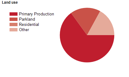
Land use
The Armidale Regional Council area is predominantly rural, with a township at Armidale, small townships at Guyra and Tingha, and villages at Ben Lomond, Black Mountain, Ebor, Hillgrove and Wollomombi. The Council area encompasses a total land area of about 8,600 square kilometres, of which a significant proportion is National Park, State Forest and nature reserves. Rural land is used largely for sheep and cattle grazing, with some fruit growing, viticulture and tourism.
Transport
The Armidale Regional Council area is served by the New England Highway, Waterfall Way, the north western railway line and Armidale Regional Airport.
Major features
- Major features of the Council area include Carrai National Park,
- Cathedral Rock National Park,
- Cunnawarra National Park,
- Guy Fawkes River National Park,
- Indwarra National Park,
- New England National Park,
- Oxley Wild Rivers National Park,
- Single National Park,
- Booroolong Nature Reserve,
- Duval Nature Reserve,
- Georges Creek Nature Reserve,
- Imbota Nature Reserve,
- Jobs Mountain Nature Reserve,
- Little Llangothlin Nature Reserve,
- Mother of Ducks Lagoon Nature Reserve,
- Serpentine Nature Reserve,
- The Basin Nature Reserve,
- Yina Nature Reserve,
- Avondale State Conservation Area,
- Carrai State Conservation Area,
- Gondwana Rainforests of Australia,
- Dumaresq Dam,
- Malpas Dam,
- part of Copton Dam,
- Mother of Ducks Lagoon,
- Llangothlin Lake,
- Little Llangothlin Lake,
- Wollomombi Gorge & Falls,
- Ebor Falls,
- various state forests,
- The Armidale CBD (including Armidale Plaza,
- Armidale Central shopping centre,
- Armidale Mall and East End Mall),
- The University of New England (Academic,
- Bellevue and CB Newling Campuses),
- TAFE New England (Armidale Campus),
- New England Conservatorium of Music,
- Armidale Hospital,
- Armidale Private Hospital,
- Armidale & Region Aboriginal Culture Centre & Keeping Place,
- Armidale Golf Club,
- Monckton Aquatic Centre,
- Armidale Racecourse,
- Armidale Sportsground,
- Armidale Sport & Recreation Centre,
- The Den (New England Regional Indoor Sports Complex),
- Armidale Showground,
- The University of New England Heritage Centre,
- Armidale Bicentennial Railway Museum,
- Armidale Folk Museum,
- Guyra & District Historical Museum,
- Guyra Antique Machinery Museum,
- Hillgrove Rural Life and Industry Museum,
- Museum of Antiquities,
- Museum of Printing,
- Wing Hing Long Museum,
- Zoology Museum,
- New England Regional Art Museum,
- Armidale Art Gallery and several wineries.
Included areas
- The Armidale Regional Council area encompasses the localities of Aberfoyle,
- Armidale,
- Backwater,
- Baldersleigh,
- Bald Blair,
- Bassendean,
- Ben Lomond (part),
- Black Mountain,
- Boorolong (part),
- Briarbrook (part),
- Brockley,
- Brushy Creek,
- Bundarra (part),
- Carrai,
- Castle Doyle,
- Dangarsleigh (part),
- Donald Creek,
- Dumaresq (part),
- Duval,
- Ebor,
- Enmore,
- Falconer,
- Georges Creek,
- Green Hills,
- Guyra,
- Hernani (part),
- Hillgrove,
- Howell,
- Jeogla,
- Kellys Plains (part),
- Kookabookra (part),
- Llangothlin,
- Lower Creek,
- Lyndhurst,
- Metz,
- New Valley,
- Oban,
- Puddledock,
- South Guyra,
- Stanborough,
- Tenterden,
- Thalgarrah,
- The Basin,
- The Gulf (part),
- Tilbuster,
- Tingha (part),
- Tubbamurra,
- Wandsworth (part),
- Wards Mistake,
- Wollomombi and Wongwibinda.