Adelaide Primary Health Network
About the profile areas
The 2023 Estimated Resident Population for the Adelaide Primary Health Network is 1,321,481, with a population density of 850.9 persons per square km.
Location and boundaries
The Adelaide Primary Health Network area encompasses the seventeen local government areas which make up the Adelaide Metropolitan area. The Adelaide Primary Health Network area is bounded by the Adelaide Plains Council area, the Light Regional Council area, the Town of Gawler and the Barossa Council area in the north, the Adelaide Hills Council area and the District Council of Mount Barker area in the east, the Alexandrina Council area and the District Council of Yankalilla area in the south, and Gulf St Vincent in the west.
Traditional Owners
The original inhabitants of the Adelaide Primary Health Network area were the Kaurna Aboriginal people.
Important
|
Population1,321,481 2023 ABS ERP |
Land area1,553 square km |
Population density850.9 persons per square km |
Settlement history
European settlement dates from 1836 when the site for Adelaide was chosen, with land surveyed in outlying areas and small villages and townships established following this. Land was used mainly for crop growing, grazing, dairy farming, market gardening, orcharding, mining and vineyards. Adelaide became the major commercial centre of South Australia, developing as a free colony without convict settlement. Industrial and residential growth took place during the 1870s and 1880s, spurred by the opening of railway lines and the tramway. Growth resumed during the early 1900s and the interwar period. Significant residential development occurred in the post-war years, aided by the establishment of a munitions factory, Edinburgh Air Force Base and South Australian Housing Trust development. Outward expansion continued from the 1960s into the 1980s. From the post-war years to the 1970s the population in the central city area steadily declined, while the population increased in areas further away from the city centre. Gradual growth occurred in most areas during the 1970s, with growth slowing during the 1980s. The population of the region increased marginally during the 1990s, rising from about 984,000 in 1991 to about 1,026,000 in 2001. Gradual growth continued from 2001, with the population rising to about 1,117,000 in 2011.
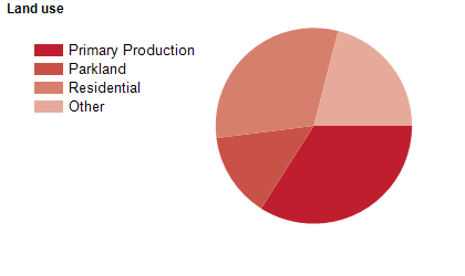
Land use
The Adelaide Primary Health Network area is urban and rural, with some commercial and industrial areas, and institutional and cultural land use in the central area. Most of the population live in established suburbs and residential estates in the central areas (closest to Adelaide), while others inhabit small coastal communities, farms and country towns in the north and south. Rural land is used mainly for viticulture, horticulture, market gardening, cropping, grazing and forestry. Tourism is also an important industry. The Adelaide Primary Health Network area encompasses a total land area of about 1,550 square kilometres.
Transport
The Adelaide Primary Health Network area is served by the South Eastern Freeway (Princes Highway), the Anzac Highway, the South Highway, the Northern Expressway, the Southern Expressway, Adelaide Airport, several railway lines, the Glenelg-Adelaide tramway and the Northeast Busway (O-Bahn).
Major features
- Major features of the area include the Adelaide Central Activities District,
- numerous other significant shopping centres (Arndale Central,
- Bayside Village,
- Burnside Village,
- Colonnades,
- Elizabeth,
- Golden Grove Village,
- Harbour Town,
- Munno Para,
- Northpark,
- Parabanks,
- Port Canal,
- Port Mall,
- Westfield Marion,
- Westfield Tea Tree Plaza and Westfield West Lakes),
- The Jetty Road commercial area in Glenelg,
- Adelaide Casino,
- Adelaide Convention Centre,
- Adelaide Entertainment Centre,
- Adelaide Event & Exhibition Centre,
- Adelaide Gaol,
- Adelaide Zoo,
- Art Gallery of South Australia,
- Coopers Brewery,
- St Kilda Adventure Playground,
- numerous hospitals (Burnside War Memorial,
- Calvary Central Districts,
- Calvary North Adelaide,
- Calvary Wakefield,
- Glenelg Community,
- Glenside,
- Griffith Rehabilitation,
- Hampstead Rehabilitation,
- Lyell McEwin,
- Modbury,
- North Eastern Community,
- Repatriation General,
- Royal Adelaide,
- St Andrew’s,
- The Memorial,
- The Queen Elizabeth and Women’s and Children’s),
- Flinders University,
- TAFE SA,
- University of South Australia,
- The University of Adelaide,
- South Australian Institute of Business & Technology,
- Belair National Park,
- Onkaparinga River National Park,
- several Conservation Parks (Aldinga Scrub,
- Hallett Cove,
- Marino,
- Moana Sands and Scott Creek),
- Aldinga Reef Aquatic Reserve,
- Port Noarlunga Aquatic Reserve,
- Kuitpo Forest,
- numerous golf courses,
- Campbelltown Leisure Centre,
- Elizabeth Aquadome,
- Marion Swimming Centre,
- Noarlunga Leisure Centre,
- SA Aquatic & Leisure Centre,
- Semaphore Waterslide Complex,
- Thebarton Aquatic Centre,
- Waterworld Aquatic Centre,
- Westlakes Aquatic Centre,
- numerous wineries,
- Army Museum of South Australia,
- Charles Sturt Museum,
- Enfield Heritage Museum,
- National Railway Museum,
- South Australia Museum,
- South Australian Aviation Museum,
- South Australian Maritime Museum,
- The Australian Museum of Childhood,
- Tramway Museum St Kilda,
- Unley Museum,
- AAMI Stadium,
- Adelaide Arena,
- Adelaide International Raceway,
- Adelaide Showgrounds,
- Adelaide Super-Drome,
- City Mazda Stadium,
- Coopers Stadium,
- Croatian Sports Centre,
- Hillcrest Stadium,
- Morphettville Racecourse,
- Netball SA Stadium,
- Prospect Oval,
- Santos Stadium,
- State Shooting Park,
- Virginia Greyhound Race Track,
- Winston Park Equestrian Centre,
- Adelaide Park Lands,
- various Recreation Parks (Anstey Hill,
- O'Halloran Hill,
- Onkaparinga River,
- Parra Wirra and Sturt Gorge),
- River Torrens Linear Park,
- Tangari Regional Park,
- Warriparinga Wetlands,
- RAAF Base Edinburgh,
- Hampstead Barracks,
- Keswick Military Barracks,
- Warradale Army Barracks,
- Fort Glanville,
- HMS Buffalo,
- Adelaide Women’s Prison,
- Yatala Labour Prison,
- Port Adelaide,
- Marina Pier (Holdfast Shores Marina),
- numerous beaches,
- several reservoirs and rivers,
- and Gulf St Vincent.
Included areas
- The Adelaide Primary Health Network area encompasses the City of Adelaide,
- The City of Burnside,
- The City of Campbelltown,
- The City of Charles Sturt,
- The City of Holdfast Bay,
- The City of Marion,
- The City of Mitcham,
- The City of Norwood,
- Payneham & St Peters,
- The City of Onkaparinga,
- The City of Playford,
- The City of Port Adelaide Enfield,
- The City of Prospect,
- The City of Salisbury,
- The City of Tea Tree Gully,
- The City of Unley,
- The Town of Walkerville and the City of West Torrens.