Alexandrina Council
About the profile areas
The 2023 Estimated Resident Population for Alexandrina Council is 30,323, with a population density of 16.60 persons per square km.
Location and boundaries
The Alexandrina Council area is located on the Fleurieu Peninsula of South Australia, about 70 kilometres south of the Adelaide CBD. The Alexandrina Council area is bounded by the District Council of Mount Barker area in the north, the Rural City of Murray Bridge in the east, Lake Alexandrina and the Southern Ocean in the south, and the City of Victor Harbor, the District Council of Yankalilla area and the City of Onkaparinga in the west.
Traditional Owners
The original inhabitants of the Alexandrina Council area were the Ngarrindjeri Aboriginal people.
Name origin
The Alexandrina Council area is named after Lake Alexandrina, which was named in 1830 after the future English Queen Victoria, then Princess Alexandrina.
Important
|
Population30,323 2023 ABS ERP |
Land area1,827 square km |
Population density16.60 persons per square km |
Settlement history
European settlement dates from the late 1830s. Growth took place from the 1840s when the township of Goolwa developed as a riverport, transporting grain, wool and produce to and from New South Wales and Victoria. Land was used mainly for sheep and cattle grazing, with some general farming. Expansion took place into the late 1800s, until river trade decreased. Significant development took place from the 1950s, particularly from the 1980s, including tourist and holiday accommodation. The population continued to increase from the 1990s.
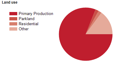
Land use
The Alexandrina Council area is a rural and rural-residential area, with growing township and holiday areas. The Council area encompasses a total land area of 1,827 square kilometres. The bulk of the population is located in the main townships of Strathalbyn, Port Elliot and Goolwa, the smaller townships of Ashbourne, Clayton Bay, Currency Creek, Finniss, Langhorne Creek, Middleton, Milang and Mount Compass, and various villages. Rural land is used largely for agriculture (dairy, beef and sheep farming), crop farming, fruit growing, viticulture, fishing and tourism.
Transport
The Alexandrina Council area is served by Victor Harbor Road.
Major features
- Major features of the Alexandrina Council area include Coorong National Park,
- Lake Alexandrina,
- Cox Scrub Conservation Park,
- Finniss Conservation Park,
- Kyeema Conservation Park,
- Mount Magnificent Conservation Park,
- Ratalang (Basham Beach) Conservation Park,
- Currency Creek Game Reserve,
- Tolderol Game Reserve,
- The Lower Murray River,
- Goolwa Wharf Precinct,
- SteamRanger Heritage Railway (The Cockle Train and The Southern Encounter),
- Hindmarsh Island,
- Goolwa Beach and several other beaches,
- Encounter Bikeway,
- Fleurieu Aquatic Centre,
- and various wineries and vineyards.
Included areas
- The Alexandrina Council area includes the localities of Angas Plains,
- Ashbourne,
- Belvidere,
- Blackfellows Creek,
- Bletchley,
- Bull Creek (part),
- Clayton,
- Currency Creek,
- Dingabledinga,
- Finniss,
- Gemmells,
- Goolwa,
- Goolwa Beach,
- Goolwa North,
- Goolwa South,
- Hartley,
- Hayborough (part),
- Highland Valley,
- Hindmarsh Island,
- Hope Forest,
- Kuitpo (part),
- Kuitpo Colony,
- Kyeema,
- Lake Plains,
- Langhorne Creek,
- Macclesfield (part),
- McHarg Creek,
- Middleton,
- Milang,
- Montarra,
- Mosquito Hill,
- Mount Compass (part),
- Mount Jagged (part),
- Mount Magnificent,
- Mount Observation,
- Mundoo Island,
- Nangkita,
- Nurragi,
- Pages Flat (part),
- Paris Creek (part),
- Point Sturt,
- Port Elliot,
- Prospect Hill (part),
- Red Creek,
- Salem,
- Sandergrove,
- Strathalbyn,
- The Range (part),
- Tolderol,
- Tooperang,
- Willunga Hill,
- Willyaroo,
- Woodchester and Yundi.