Albury City
About the profile areas
The 2023 Estimated Resident Population for Albury City is 57,517, with a population density of 188.2 persons per square km.
Location and boundaries
Albury City is located in the Murray Statistical Division of New South Wales, just north of the Victorian border, about 310 kilometres north-east of Melbourne and 570 kilometres south-west of Sydney. Albury City is bounded by Greater Hume Shire in the north, east and west and the Murray River in the south.
Traditional Owners
The original inhabitants of the Albury area were the Wiradjuri Aboriginal people.
Important
|
Population57,517 2023 ABS ERP |
Land area305.6 square km |
Population density188.2 persons per square km |
Settlement history
European settlement dates from 1835. The land was used mainly for farming and grazing, with a small village established in the 1840's. Growth was minimal until the 1850's, when Albury became a vital river port for paddle-steamers. More substantial growth took place from the late 1870's, the catalyst being the opening of the railway line from Sydney. The most significant development occurred in the post-war years, with the population increasing from about 15,000 in 1946 to about 37,000 in 1981. Substantial growth took place during the 1970's and 1980's, when Albury-Wodonga was designated as a national growth centre and the Albury Wodonga Development Corporation was established. The population of the City increased from nearly 43,000 in 1991 to over 44,000 in 1996, and then remained relatively stable between 1996 and 2001. The population increased from 2001, rising to nearly 48,000 in 2011. Much of the recent growth has been in Thurgoona, Hamilton Valley and East Albury.
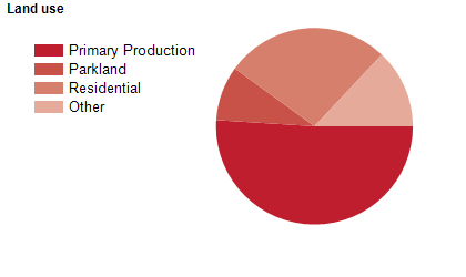
Land use
Albury City includes the main urban centre of Albury, as well as substantial industrial, commercial, recreational and parkland areas and significant rural hinterland. The City encompasses a total land area of about 332 square kilometres. The majority of the population lives in the central and southern suburbs of Albury, Lavington, North Albury, South Albury, Springdale Heights and Thurgoona. The rural land is used for mixed agricultural purposes.
Transport
Albury is ideally located logistically, connected to Sydney, Canberra and Melbourne by the Hume Freeway and directly linked regionally via the Kiewa Valley Highway, the Murray Valley Highway and the Riverina Highway. The Sydney to Melbourne railway line runs through Albury and regular flights from Albury Airport, some five minutes from the CBD, connect the city to Sydney, Melbourne, Canberra and the Latrobe Valley.
Major features
- Major features of the City include the Murray River,
- Lake Hume,
- Hume Weir,
- Wonga Wetlands,
- Mungabareena Reserve,
- Nail Can Hill Reserve,
- Albury LibraryMuseum,
- Albury Art Gallery,
- Albury Botanic Gardens,
- Albury Entertainment Centre,
- Monument Hill Lookout,
- The Albury City Centre with its historic buildings,
- vibrant cafes and boutiques,
- Centro Lavington Shopping Centre,
- The historic Albury Railway Station and Albury Wodonga Health (Albury Campus). Albury is well served with public and private schools,
- including one co-educational boarding school. Tertiary institutions in Albury are the Charles Sturt University (Albury-Wodonga City and Thurgoona Campuses) and TAFE NSW Riverina Institute (Albury Campus and National Environment Centre).
Included areas
- Albury City includes the suburbs and localities of Albury,
- East Albury,
- Ettamogah,
- Glenroy,
- Hamilton Valley,
- Lake Hume Village,
- Lavington,
- North Albury,
- South Albury,
- Splitters Creek,
- Springdale Heights,
- Table Top (part),
- Thurgoona,
- West Albury and Wirlinga.