Adelaide Plains Council area
About the profile areas
The 2023 Estimated Resident Population for Adelaide Plains Council area is 10,932, with a population density of 11.70 persons per square km.
Location and boundaries
The Adelaide Plains Council area is located in the western part of the Barossa Region, about 60 kilometres north of the Adelaide CBD. The Adelaide Plains Council area is bounded by the Wakefield Regional Council area in the north, the Light Regional Council area in the east, the City of Playford in the south, and Gulf St Vincent in the west.
Traditional Owners
The original inhabitants of the Adelaide Plains Council area were the Kaurna Aboriginal people.
Important
|
Population10,932 2023 ABS ERP |
Land area934.7 square km |
Population density11.70 persons per square km |
Settlement history
European settlement of the area dates from the 1840s, with land used mainly for grain growing and sheep grazing. Gradual growth took place from the 1860s into the early 1900s, when many small townships were established, aided by the opening of the railway line in 1917. The population increased from the early 1990s, with the most rapid growth between 1991 and 1996, with the number of people rising from about 5,000 in 1991 to nearly 9,000 in 2016. Growth is expected in the future, largely due to the proposal to rezone land in Two Wells.
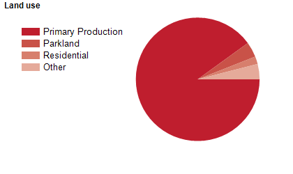
Land use
The Adelaide Plains Council area is predominantly rural with growing townships. The Council area has a large tidal coastal region facing the Gulf of St Vincent. Rural land is used largely for agriculture, particularly wheat, barley, lucerne and hay production, with some tomato growing. The main townships are Dublin, Mallala and Two Wells, with small coastal settlements at Middle Beach, Parham and Thompson Beach. The Council area encompasses a total land area of about 930 square kilometres.
Transport
The Adelaide Plains Council area is served by Port Wakefield Road.
Major features
- Major features of the Council area include Port Gawler Conservation Park,
- Gulf St Vincent,
- various beaches,
- Two Wells Golf Club,
- Mallala Motor Sport Park,
- Mallala Museum,
- Rockies Reserve and Verdale Olive Estate.
Included areas
- The Adelaide Plains Council area includes the localities of Barabba (part),
- Calomba,
- Dublin,
- Fischer,
- Grace Plains (part),
- Korunye,
- Lewiston,
- Long Plains (part),
- Lower Light,
- Mallala,
- Middle Beach,
- Parham,
- Port Gawler (part),
- Redbanks,
- Reeves Plains (part),
- Thompson Beach,
- Two Wells,
- Webb Beach,
- Wild Horse Plains (part) and Windsor.